Cape Arago's Eight Parks
![OR: Coos County, Coos Bay Area, Cape Arago Parks, Yoakam Point State Park, View from the sea cliffs towards Cape Arago Lighthouse. [Ask for #276.161.]](./imgstore/276.161.jpg)
Cape Arago Lighthouse viewed from Yoakam Point, part of Sunset Bay State Park in Cape Arago's park complex. [Ask for #276.161.]
Located just outside Coos Bay, the eight parks of the Cape Arago Peninsula offer some of the finest coastal scenery between Big Sur and Olympia — sea cliffs, beaches, a nature reserve with relic logging features, and a formal garden. All parks are free except the gardens of Shore Acres and all are reached by paved highways.
There's a map at the bottom of this page.
Bastendorff Beach County ParkThis county park, just west of Charleton, features a wide beach and views towards the cliffs of Yoakam Point and Coos Head. It has RV camping and picnicking.![OR: South Coast Region, Coos County, Coos Bay Area, Cape Arago Parks, Yoakam Point State Park, View from Yoakam Point back towards Bastendorff Beach [Ask for #276.181.]](./imgstore/276.181.jpg) OR: South Coast Region, Coos County, Coos Bay Area, Cape Arago Parks, Yoakam Point State Park, View from Yoakam Point back towards Bastendorff Beach [Ask for #276.181.] |
![OR: South Coast Region, Coos County, Coos Bay Area, Cape Arago Parks, Bastendorff Beach County Park, View over Bastendorff Beach towards the cliffs of Yoakam Point [Ask for #274.845.]](./imgstore/274.845.jpg) OR: South Coast Region, Coos County, Coos Bay Area, Cape Arago Parks, Bastendorff Beach County Park, View over Bastendorff Beach towards the cliffs of Yoakam Point [Ask for #274.845.] |
 OR: Coos County, Coos Bay Area, Cape Arago Parks, Bastendorff Beach County Park, View towards Yoakam Point [Ask for #276.213.] |
![OR: Coos County, Coos Bay Area, Cape Arago Parks, Yoakam Point State Park, View from Yoakam Point back towards Bastendorff Beach [Ask for #276.177.]](./imgstore/276.177.jpg) OR: Coos County, Coos Bay Area, Cape Arago Parks, Yoakam Point State Park, View from Yoakam Point back towards Bastendorff Beach [Ask for #276.177.] |
Yoakam PointAlthough unsigned and unmarked, this tract is part of the state parks system. It offers sweeping cliff views towards Cape Arago Lighthouse and Bastendorff Beach. It has no facilities other than informal trails and a small parking area.![OR: Coos County, Coos Bay Area, Cape Arago Parks, Yoakam Point State Park, View from the sea cliffs, over the beach below, towards Cape Arago Lighthouse. [Ask for #276.151.]](./imgstore/276.151.jpg) OR: Coos County, Coos Bay Area, Cape Arago Parks, Yoakam Point State Park, View from the sea cliffs, over the beach below, towards Cape Arago Lighthouse. [Ask for #276.151.] |
|
![OR: Coos County, Coos Bay Area, Cape Arago Parks, Yoakam Point State Park, View from the sea cliffs, over the beach below, towards Cape Arago Lighthouse. [Ask for #276.165.]](./imgstore/276.165.jpg) OR: Coos County, Coos Bay Area, Cape Arago Parks, Yoakam Point State Park, View from the sea cliffs, over the beach below, towards Cape Arago Lighthouse. [Ask for #276.165.] |
![OR: South Coast Region, Coos County, Coos Bay Area, Cape Arago Parks, Yoakam Point State Park, View from the sea cliffs, over the beach below. [Ask for #276.152.]](./imgstore/276.152.jpg) OR: South Coast Region, Coos County, Coos Bay Area, Cape Arago Parks, Yoakam Point State Park, View from the sea cliffs, over the beach below. [Ask for #276.152.] |
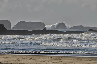
Sunset Bay State ParkThe first of three formal state parks on the Cape Arago Highway centers on a circular, cliff-lined cove with sandy beaches. A developed foot trail follows the cliffs south of the bay. The park has beach swimming, picnicking, boat launching, and RV camping.![OR: Coos County, Coos Bay Area, Cape Arago Parks, Norton Gulch Viewpoint, Sea kayaker enters an isolated cove. [Ask for #276.367.]](./imgstore/276.367.jpg) OR: Coos County, Coos Bay Area, Cape Arago Parks, Norton Gulch Viewpoint, Sea kayaker enters an isolated cove. [Ask for #276.367.] |
![OR: Coos County, Coos Bay Area, Cape Arago Parks, The Bay, Golden sand beach surrounded by cliffs; people launch boat from beach [Ask for #274.013.]](./imgstore/274.013.jpg) OR: Coos County, Coos Bay Area, Cape Arago Parks, Sunset Bay State Park, Sunset Bay, Golden sand beach surrounded by cliffs; people launch boat from beach [Ask for #274.013.] |
![OR: Coos County, Coos Bay Area, Cape Arago Parks, Sunset Bay Cliffs, View towards Cape Arago Lighthouse [Ask for #276.299.]](./imgstore/276.299.jpg) OR: Coos County, Coos Bay Area, Cape Arago Parks, Sunset Bay Cliffs, View towards Cape Arago Lighthouse [Ask for #276.299.] |
|
![OR: South Coast Region, Coos County, Coos Bay Area, Cape Arago Parks, Sunset Bay State Park, Sunset Bay Cliffs, Cliff-top bench [Ask for #276.307.]](./imgstore/276.307.jpg) OR: South Coast Region, Coos County, Coos Bay Area, Cape Arago Parks, Sunset Bay State Park, Sunset Bay Cliffs, Cliff-top bench [Ask for #276.307.] |
Shore Acres State Park Cliff WalkShore Acres, Cape Arago's most developed park, has three distinct areas: a cliff walk, a formal garden, and a wildlife overlook. The half-mile cliff walk is first, starting at Norton Gulch Overlook and heading south to the gardens. (There's a fee for parking at the gardens.)![OR: Coos County, Coos Bay Area, Cape Arago Parks, Shore Acres Cliffs, Path leads down steps along a cliff-top forest [Ask for #276.356.]](./imgstore/276.356.jpg) OR: Coos County, Coos Bay Area, Cape Arago Parks, Shore Acres Cliffs, Path leads down steps along a cliff-top forest [Ask for #276.356.] |
![OR: Coos County, Coos Bay Area, Cape Arago Parks, Shore Acres Cliffs, View over sea cliffs towards the Shore Acres overlook pavillon [Ask for #276.361.]](./imgstore/276.361.jpg) OR: Coos County, Coos Bay Area, Cape Arago Parks, Shore Acres Cliffs, View over sea cliffs towards the Shore Acres overlook pavillon [Ask for #276.361.] |
![OR: Coos County, Coos Bay Area, Cape Arago Parks, Shore Acres Cliffs, High surf pounds against sea cliffs [Ask for #276.220.]](./imgstore/276.220.jpg) OR: Coos County, Coos Bay Area, Cape Arago Parks, Shore Acres Cliffs, High surf pounds against sea cliffs [Ask for #276.220.] |
Gardens at Shore Acres State ParkA local timber baron built a mansion with a formal garden on this site in 1907, then sold the entire property to the state in 1942 for use as a park. The state government badly neglected this park for its first three decades, abandoning the gardens and razing the mansion to avoid repairing it. Then in 1974 the state began restoring the garden to its former plan. There is a $5 parking fee.![OR: Coos County, Coos Bay Area, Cape Arago Parks, Shore Acres Garden, Garden view [Ask for #274.016.]](./imgstore/274.016.jpg) OR: Coos County, Coos Bay Area, Cape Arago Parks, Shore Acres Garden, Garden view [Ask for #274.016.] |
![OR: Coos County, Coos Bay Area, Cape Arago Parks, Shore Acres Garden, Garden view; garden house [Ask for #274.024.]](./imgstore/274.024.jpg) OR: Coos County, Coos Bay Area, Cape Arago Parks, Shore Acres Garden, Garden view; garden house [Ask for #274.024.] |
![OR: Coos County, Coos Bay Area, Cape Arago Parks, Shore Acres Garden, Garden view; heron statues in pond [Ask for #274.021.]](./imgstore/274.021.jpg) OR: Coos County, Coos Bay Area, Cape Arago Parks, Shore Acres Garden, Garden view; heron statues in pond [Ask for #274.021.] |
![OR: Coos County, Coos Bay Area, Cape Arago Parks, Shore Acres Garden, Garden view; pond with sculpture [Ask for #274.023.]](./imgstore/274.023.jpg) OR: Coos County, Coos Bay Area, Cape Arago Parks, Shore Acres Garden, Garden view; pond with sculpture [Ask for #274.023.] |
Simpson Reef ViewpointPart of Shore Acres State Park, the Simpson Reef Viewpoint is noted for its plentiful, and very loud, sea lions, easily viewed from the overlook.![OR: Coos County, Coos Bay Area, Cape Arago Parks, Simpson Reef Viewpoint, California Sea Lions lay thick on the exposed rock outcrops that make up the reef [Ask for #274.915.]](./imgstore/274.915.jpg) OR: Coos County, Coos Bay Area, Cape Arago Parks, Simpson Reef Viewpoint, California Sea Lions lay thick on the exposed rock outcrops that make up the reef [Ask for #274.915.] |
|
![OR: Coos County, Coos Bay Area, Cape Arago Parks, Simpson Reef Viewpoint, View of Simpson Reef Overlook. [Ask for #274.918.]](./imgstore/274.918.jpg) OR: Coos County, Coos Bay Area, Cape Arago Parks, Simpson Reef Viewpoint, View of Simpson Reef Overlook. [Ask for #274.918.] |
![OR: Coos County, Coos Bay Area, Cape Arago Parks, Simpson Reef Viewpoint, Sea cliffs [Ask for #274.030.]](./imgstore/274.030.jpg) OR: Coos County, Coos Bay Area, Cape Arago Parks, Simpson Reef Viewpoint, Sea cliffs [Ask for #274.030.] |
Cape Arago State ParkThis park at the end of its namesake highway sits on the cape itself, with numerous views. Picnicking includes a number of cliff-edge tables.![OR: Coos County, Coos Bay Area, Cape Arago Parks, Cape Arago Viewpoint, Sea cliffs [Ask for #274.026.]](./imgstore/274.026.jpg) OR: Coos County, Coos Bay Area, Cape Arago Parks, Cape Arago Viewpoint, Sea cliffs [Ask for #274.026.] |
![OR: Coos County, Coos Bay Area, Cape Arago Parks, South Cove, Path leading down the cliffs through forests [Ask for #276.370.]](./imgstore/276.370.jpg) OR: Coos County, Coos Bay Area, Cape Arago Parks, South Cove, Path leading down the cliffs through forests [Ask for #276.370.] |
![OR: South Coast Region, Coos County, Coos Bay Area, Cape Arago Parks, Cape Arago State Park, South Cove, A path descends the cliffs to give wide views over South Cove and The Seven Devils, a line of cliffs [Ask for #276.383.]](./imgstore/276.383a.jpg) OR: South Coast Region, Coos County, Coos Bay Area, Cape Arago Parks, Cape Arago State Park, South Cove, A path descends the cliffs to give wide views over South Cove and The Seven Devils, a line of cliffs [Ask for #276.383.] |
|
![OR: Coos County, Coos Bay Area, Cape Arago Parks, South Cove, A young woman sits upon a sea rock [Ask for #276.377.]](./imgstore/276.377.jpg) OR: Coos County, Coos Bay Area, Cape Arago Parks, South Cove, A young woman sits upon a sea rock [Ask for #276.377.] |
South Slough Estuarine PreserveThe newest and largest of the eight parks sits on the leeward side of the Cape Arago Peninsula. It has well developed trail system with a number of long boardwalks over marshes and along streams. The area was heavily logged and relics of those days can be impressive. The two trailheads are widely spaced. The visitor's center has a good museum.![OR: Coos County, Coos Bay Area, Cape Arago Parks, South Slough National Estuarine Reserve, The Sloughside Trail follows a levee that once impounded Sloughside Marsh as part of early 20th C logging operations, w logging RR pilings on the slough side. [Ask for #274.908.]](./imgstore/274.908.jpg) OR: Coos County, Coos Bay Area, Cape Arago Parks, South Slough National Estuarine Reserve, The Sloughside Trail follows a levee that once impounded Sloughside Marsh as part of early 20th C logging operations, w logging RR pilings on the slough side. [Ask for #274.908.] |
![OR: Coos County, Coos Bay Area, Cape Arago Parks, South Slough National Estuarine Reserve, Hidden Creek Trail enters a green tunnel on wood steps [Ask for #274.851.]](./imgstore/274.851.jpg) OR: Coos County, Coos Bay Area, Cape Arago Parks, South Slough National Estuarine Reserve, Hidden Creek Trail enters a green tunnel on wood steps [Ask for #274.851.] |
![OR: Coos County, Coos Bay Area, Cape Arago Parks, South Slough National Estuarine Reserve, Hidden Branch Boardwalk, in the dense forests at the mouth of Hidden Branch [Ask for #274.868.]](./imgstore/274.868.jpg) OR: Coos County, Coos Bay Area, Cape Arago Parks, South Slough National Estuarine Reserve, Hidden Branch Boardwalk, in the dense forests at the mouth of Hidden Branch [Ask for #274.868.] |
![OR: Western Oregon, Coos County, Coos Bay Area, Cape Arago Parks, South Slough National Estuarine Reserve, Wood bridge over Winchester Creek, at the kayak launch ramp [Ask for #276.408.]](./imgstore/276.408.jpg) OR: Western Oregon, Coos County, Coos Bay Area, Cape Arago Parks, South Slough National Estuarine Reserve, Wood bridge over Winchester Creek, at the kayak launch ramp [Ask for #276.408.] |
![OR: South Coast Region, Coos County, Coos Bay Area, Cape Arago Parks, South Slough National Estuarine Reserve, Wood bridge over Winchester Creek, at the kayak launch ramp [Ask for #276.411.]](./imgstore/276.411.jpg) OR: South Coast Region, Coos County, Coos Bay Area, Cape Arago Parks, South Slough National Estuarine Reserve, Wood bridge over Winchester Creek, at the kayak launch ramp [Ask for #276.411.] |
![OR: Coos County, Coos Bay Area, Cape Arago Parks, South Slough National Estuarine Reserve, The Sloughside Trail follows a levee that once impounded Sloughside Marsh as part of early 20th C logging operations, w logging RR pilings on the slough side. [Ask for #274.904.]](./imgstore/274.904.jpg) OR: Coos County, Coos Bay Area, Cape Arago Parks, South Slough National Estuarine Reserve, The Sloughside Trail follows a levee that once impounded Sloughside Marsh as part of early 20th C logging operations, w logging RR pilings on the slough side. [Ask for #274.904.] |
|
The Cape Arago Peninsula![OR: South Coast Region, Coos County, Coos Bay Area, Cape Arago Parks, Map of the six Cape Arago parks [Ask for #990.132.]](./imgstore/990.132.png) Map of the six parks on the Cape Arago peninsula. [Ask for #990.132.] |
|
|
OR: Western Oregon, Coos County, Coos Bay Area, Cape Arago Parks, South Slough National Estuarine Reserve, Wood bridge over Winchester Creek, at the kayak launch ramp [Ask for #276.408.] |
|
|
| |
BlogPacifica.Com
Exploring the Pacific Coast
e-mail: jim@blogPacifica.com
Exploring the Pacific Coast
e-mail: jim@blogPacifica.com
Copyright ©2023, James A Hargan. All rights reserved.
All maps created using data from DeLorme Topo North America® v9.0, ©2010 DeLorme®
(www.deLorme.com)
Contact the webmaster at
maven@harganonline.com